Mile 0
Welcome to the Cannon Valley Trail. At this point, the Cannon Falls city trails merge with the Cannon Valley Trail. The Archie Swenson Fields access will be coming up shortly. Trail attendants service the information booth on weekends April – October. Parking, restrooms are available.
Mile 1.6 – Prairie
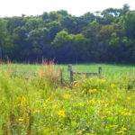
Trail lands contain dry prairie species such as big blue-stem, side oats gamma, pasque flower and state-threatened Kittentails. Color is a its peak in mid – late summer.
Mile 2.4 – (M76) The Big Fill
Originally a 400 foot long railroad bridge spanned this ravine but in 1916 it was removed and filled in. Water now flows through concrete tubes 40′ below the trail’s surface.
Mile 2.6 – Scenic Overlook
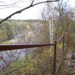
Pull over and admire the Cannon River 40′ below. The largest of SE Minnesota rivers, it begins in Rice County and empties into the Mississippi River 100 miles later.
Mile 3.0 – Borrow Pit
You are now standing at the edge of a railroad-era gravel pit. This soil was believed to have been disturbed in 1916 when the materials were removed for the big fill.
Mile 3.4 (M77) – Moist Cliffs
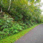
This cool, north facing cliff of dolomite (type of limestone) is covered with moss lichen, forest floor specimens such as wild ginger and ferns. Numerous fern species like the uncommon Slender Cliffbrake and Walker Fern have been identified.
Mile 3.8 – Anderson Memorial Rest
A hardwood forest of sugar maple, black walnut and ash surround this peaceful spot along a trout stream. Facilities include a picnic area, toilets, a 1/2 mile loop hiking tail, and fishing access along the Cannon River. A favorite summer activity is to splash in the clean, cool waters of the stream. Unnamed and about 1/3 mile long, this spring-fed stream averages less than 12 inches deep and 5 feet wide.
Mile 4. 6 – Conservation Zone
Despite averaging only 100 feet in width, portions of the trail have outstanding ecological value. Two such areas have been designated Conservation Zones. To protect the fragile resources present, off-trail exploration in this vicinity is prohibited, except to the cave-like rock lean-to 200 yard west of here.
Mile 5.3 (150 yards west of M79) Sod House Location
Look carefully for the square sided holes cut into the slop of the south side the trail. Local oral history has it that this was the site of an early pioneer sod house which served as shelter until a more substantial home could be built.
Mile 6.1 – MN DNR Recreational Trail
Land on both sides of the trail is owned by the MN Department of Natural Resources. The trail on the south side is a 1.5 mile loop through state forestland. River Terrace Prairie State Natural Area is visible ride to the northwest. Prairie restoration is planned for the base of the slopes. Sensitive hiking is the only use allowed. Miesville Park Preserve is located across the river. The area encompasses about 1,800 acres including about 1 miles of river frontage.
Mile 6.4 (M80)- Train Wreck Site
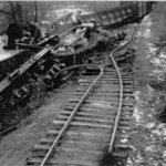
Local legend has it that in about 1912 there was a major train wreck here which spilled the cargo of rough cut granite thought to be used for tombstones. Over 100 blocks rest on the hillside between the road and the river, with one on display at the Milepost 80 marker. Originally at this curve the railroad tracks were where the road is now. The stones range from suitcase size to grand piano dimensions with a few in the river. They are often difficult to see during full foliage.
Mile 7.1 – Mid-Continent Gun Club
This is a private, well managed, gun range adjacent tot he trail. Controlled and safe conditions exist but sudden noise can sometimes startle. Enjoy their hospitality and rest in the shade at the bench they provide.
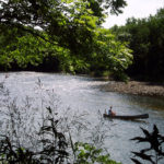
Mile 8.3 (M82) – River Recreation
A state designated canoe route, the Cannon River offers a nearly perfect combination of pools, riffles, and mild rapids for canoeing, inner tubing and kayaking. Rental and shuttle services are available in Welch and Cannon Falls.
Mile 8.9 – Hidden Valley Campground
This Campground is closed and no longer in use. This is private land and not to be explored.
Mile 9.1 – Abandoned River Channel
Rivers meander through their floodplains, changing course to follow the path of least resistance. The Cannon River has done this many times and left as obvious evidence the small wooded wetland on the north side of the trail./ This depression is well used by frogs and other common wetland animals.
Mile 9.8 – Welch Station Access / Welch Village
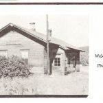
Welch Station was once a thriving railroad service area. including stockyards, coal shed, lumber yard, depot and more. This 3 acre site now houses the Trail’s maintenance headquarters and offers parking, toilets, water, and picnic tables. Welch Station Access is the mid-point of the Trail between Cannon Falls and Red Wing. Trail attendants service the information booth on weekends April – October. The village of Welch is 3 blocks to the north along County 7 Blvd. Food, snacks, beverages, and canoe and tube rental are available.
Mile 10.4 (M84) Dedication Sign / Welch Village Ski Area
The trail was dedicated May 31, 1986. this sign displays the logos of the railroads involve in the Cannon Valley line. Welch Village Ski Area dominates the slopes to the south of the trail. Welch Village has over 30 downhill runs with over 300 feet of vertical drop.
Mile 10.9 – Bluff Prairies
Look north to the bluffs and find more open areas. These are bedrock bluff dry prairies (also called goat, or hill prairies). Hot, dry, south-facing slopes with thin soils, support a prairie of short grasses such side oats gamma, and little blue stem.
Mile 11.4 – Marshal Memorial Rest / Belle Creek
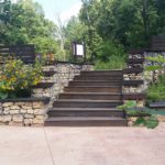
The Marshall Memorial Rest Area offers 2 plaza levels, connected by steps and a ramp. The gabion baskets are filled with locally sourced stone and arranged to reflect local geology – glacial drift over bedrock. Information is available about the Belle Creek Watershed and Railroad era artifacts. You will also find seating area and short trail under the bridge that lead to the creek. A seasonal fire pit can also be found ( for winter use only) Belle Creek is a major tributary of the Cannon River and frequently floods. The Chicago Great Western Railroad tracks from here to County 7 Blvd where often put of of service. This floodplain area is rich in wildlife, especially forest bird species such as wild turkey and pileated woodpecker.
Mile 11.7 – Pioneer Roads
Look carefully at the slope to the south and find remnants of an old road. Maps of 1894 show this road and the platted but never developed, town of Belle Creek.
Mile 12.3 – Cannon River Turtle Preserve
 Floodplain forest between here and the Cannon River is now part of a preserve to provide refuge for the state-threatened Wood Turtle (clemmys insculpta). The wood turtle is semi-terrestrial spending more time out of water than the common painted turtle, often seen sunning on the logs. It wanders the forest in search of berries, succulent leaves, and insects.
Mile 13.7 – Gravel Extraction
The high quality gravel of this terrace, sorted and deposited by the glacial melt waters, are excavated for use in read and other construction projects. A population of Kittentails was found in this area.
Mile 13.9 – Cannon River
 The Cannon River drains 1,462 square miles of which 93% is occupied by agriculture. The River’s source has an elevation of 1,068′ and discharges into the Mississippi River near Red Wing at 675′. Flooding is frequent as the absorbent capabilities of the watershed have been diminished due to the loss of wetlands, land clearing and urbanization. At least 5 species of turtle make the river, wetlands and forests home. At least two of these species use this portion of the trail for nesting – the painted turtle and snapping turtle climb the river banks to lay their eggs. Please do not disturb any time turtles.
Mile 14.4 (M88) Flood Evidence
Several times in the Trail’s first 10 years of operation, floodwaters from the Cannon River poured over the top of the trail at this location. The railroad placed huge limestone blocks along the river side in attempt to reduce the damage.
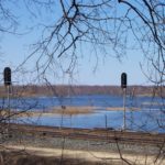
Mile 15.0 – Highway 61 Rest Area / Railroad Flycather
In 1994, the MN DOT constructed this rest area for trail visitors. the location provides a view of the surrounding flood plain, some of which is the lower unit of the Cannon River Turtle Preserve SNA. Look east and notice the railroad era artifact, called a “fly-catcher” or “tell-tale”. Dangling rope serve a visual reminder of the maximum height the train cargo could be and still safe to pass under the bridge.
Mile 15.4 – Cannon Bottom Road Access
Parking and restrooms are available at this location. Self Pay stations are available for you to purchase your trail pass. No attendants on duty at this location.
Historic Road Crossing
The Mendota to Wabasha Military Road, completed in late 1856, connected 2 points of military interest at that time. Cannon Bottom Road, starting just north of the trail, is a well preserved 3,200 foot long section of this route and is listed one the National Register of Historic Places.
Cannon Bottoms Road is closed between Cannon Valley trail on the south and Collischan Rd on the north. On this 0.6 mile [1 km] stretch of road there are three historic, abandoned bridges. Two trusses and one concrete T-beam. This is the north most bridge spanning the main channel of the river. The other two bridges are steel trusses.
Mile 15.6 – Watercress
Non-native, edible watercress covers the cold and clear waters of this stream. Springs, found along the base of the slope, create the stream which stays open all year long. In order to protect the natural resources, please do not disturb the plant, flower, wildlife or other natural or cultural resources along the trail.
Mile 15.8 Wetland Observation Deck
These native wetlands are located in the Mississippi Flyway, an important migration corridor. The wetlands provide a habitat for several native bird, plant and insect species. For those who want to hike a bit, Marshall Reforestation Project offers a half mile pedestrian trail on the south side of the trail.
Mile 16.2 Thompson Archaeological Site / Red Wing Archaeological Preserve
This 26 acre site is a Middle Mississippian village site, believed to be from the Silvernale phase (ca. AD 1050-1300) so named because of the certain ceramic styles used. This entire village site, which includes the Thompson Archaeological Site and the Red Wing Archaeological Preserve, is a complex of 64 mounds know as the Temple Mound Group. At the heart of this group in a rectangular mound. Mounds of this type are exceptionally rate and culturally significant. In Middle Mississippian and related societies, these mounds were often used as the basis for homes or burial locations of the social elite of a village. While the presence of Middle Mississippian peoples in Red wing remains debatable, this mound is one the strongest indications of their influences here, and it remains the only mound of its type in Minnesota. . A connecting path from the Cannon Valley Trail to the site climbs 90′ and has 54 steps. This site is a fragile record of past lives therefore should be treated with respect.
Mile 16.2 Camp Pearson
In the late 1930’s First Lutheran Church of Red Wing constructed a church camp at this site. Today the only remnants of the camp are a standing fireplace, several dispersed sections of mortar brick, a red tile stairway down tot he Cannon Rive and cylindrical tile pit. this 8 acre parcel was sold to the Cannon Valley Trail in 2001 and is now a favorite nesting area for wood turtle.
Mile 17.4 Silvernale Archaeological Site
This 8 a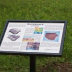 cre parcel of land contains a large archaeological site that included a large village complex dating back nearly 800 years. Using geophysical surveying techniques, archaeologists were able to locate an ancient house basin. The house was approximately 7 meters across and consisted of vertical wooden posts. They also discovered a large pottery fragment possibly used for serving food or storing water. This site is a fragile record of past lives, there should be treated with respect.
Mile 17.7 Wetlands
View the Cannon Bottoms, 2.700 acres owned by the Red Wing Wildlife League and manged for wildlife, Five rivers and creek mix here and there are about eight named shallow lake/marsh basins, causing this area to be frequently impacted by floods and sedimentation. The skies here can be busy each spring and fall as numerous bird species migrate along the Mississippi Flyway. Portions of the bottoms are designated migratory bird resting and feeding areas.
Mile 18.1 Trail Extension
Here the trail forks. The Extension to the south travels 1/3 mile to Lower A.P. Anderson Park. Stay to the north and you will find 1.5 miles of trial which ends at the Old West Main Access.
Mile 19.7 – Old West Main Access
This is the end of the Cannon Valley Trail. In the future we hope to be connect here with other area trails. Street routes will take you to downtown Red Wing destinations. This access has parking, toilets, and information.
South Extension –
Goodhue County Poor Farm & Cemetery
This area of land once was part of Minnesota’s first and last County Poor Farm. The site was selected in 1864 and it was hoped that the poor, working this farm could become self-supporting. By the time operations ceased in 1963, 1,500 people had found relief. The cemetery is the final resting place of 43 former residents.
Lower A.P. Anderson Park
Cannon Valley Trail ends at this park. The City of Red Wing trail connects to Upper Anderson Park.
